37
cherifici, magazzini di stoccaggio
dei prodotti cerealicoli, stabilimenti
che sfruttano la compresenza delle
due principali vie di comunicazione
e di trasporto, rappresentate dalla
ferrovia e dal Po di Volano.
Questo tessuto produttivo che
viene sempre più densificandosi, si
arricchisce agli inizi del Novecento
dei principali nuovi servizi tecnici
di scala urbana, di cui Ferrara ini-
zia a dotarsi, e che non trovano
collocazione all’interno della città
murata: il mercato ortofrutticolo
(Mof), la centrale dell’Enel, il
deposito dei mezzi tramviari
comunali (Atam), i primi depositi
di stoccaggio di prodotti petroli-
feri, il gasometro, la darsena flu-
viale.
Nei primi anni del secondo dopo-
guerra, questi ambiti, fortemente
caratterizzati dal concentrarsi di
funzioni specialistiche, iniziano ad
esaurire la loro attività produttiva
e dalla fine degli anni Settanta ad
oggi, divengono oggetto di un
lento e progressivo processo di
dismissione e di delocalizzazione,
in aree meglio servite dalla nuova
viabilità di scorrimento.
In alcuni casi, abbandonata la fun-
zione originaria, si è assistito ad
un faticoso tentativo di rivitalizza-
zione, con l’inserimento di nuove
attività prevalentemente commer-
ciali, che non hanno avuto suc-
cesso, quasi a dimostrare l’incapa-
cità / impossibilità, per tali aree di
assumere un nuovo ruolo, in
assenza di radicali interventi di
riqualificazione.
The area. Urban setting
and planning for the area
The area in which the MEIS will be
located is in the south west part of
the city, in the section that was
incorporated into the walled city by
the gradual and inexorable drying
up of the ancient branch of the Po
di Ferrara, now the Po di Volano.
This area, where originally there
were market gardens, was slowly
subsumed by the early urban
expansion of the city beyond the
confines of the Thirteenth Century
walls where via Ripagrande now
lies, and later enclosed by the new
fortified walls built in the Sixteenth
Century.
From the mid-Eighteenth Century
to the Second World War, this area
lying outside the walls between
the defensive system of the valley
and the river became the first
industrial zone. Here would have
been found flax mills, hemp mills,
sugar refineries, warehouses
for cereals, and other industries
that took advantage of the
position between the two major
communication corridors of the
time: the railway and the Po di
Volano river.
This industrial zone became ever
more densely packed. In the early
Twentieth century, it was enriched
by the new city wide services that
congregated outside the city walls
of Ferrara: the fruit and vegetable
market (MOF), the electric power
station, the bus and tram station
(ATAM), the first storage depots
for petroleum products, the
gasometer, and the river basin.
In the years immediately following
the Second World War, the highly
specialized
industries
that
characterized this area began to
wind up their activities. From the
end of the 1970’s to today, the
area slowly declined, marked
by closures and relocations to
areas better served by the new
transportation networks.
This area was largely abandoned
when efforts began to revitalize it.
New commercial activities sprung
up, but were ultimately unsuccessful,
confirming the inability/impossibility
of this locality be viable without
radical redevelopment.
Collectively,
the
businesses
described above, given their
strategic position between the
historical city centre and the
suburbs,
were
immediately
recognized as a part of a viable
sector for redevelopment by the
Regulatory Plan of 1995, which
established the first principal
strategy for revitalizing the area
between the city walls and the Po
di Volano.
Their strategic value was defined in
1996, the year following the
approval of the Regulatory Plan, at
the conference “V for Volano,” in
which the new role of the area
was envisioned as being
incorporated within the entire
urban conglomeration. Their
central location with respect to the
historical city and the Twentieth
century city, created an image for
the construction of a new centre, a
type of new axis of the Giovecca,
a centre for the new services that
the historic centre needed. This
P
AOLO
P
ERELLI
L’ambito urbano in cui viene a col-
locarsi il Museo Nazionale del-
l’Ebraismo Italiano e della Shoah è
quello della zona sud ovest della
città, nelle aree inglobate nella
cinta muraria a seguito del progres-
sivo ed inesorabile inaridimento
dell’antico ramo del Po di Ferrara,
ora Po di Volano.
Tali aree, originariamente sede di
orti urbani, vengono lentamente
saturati dalle prime espansioni edi-
lizie della città oltre l’antico limite
delle mura trecentesche della via
Ripagrande, e successivamente
racchiusi nella nuova cinta difen-
siva delle mura cinquecentesche.
Oltre le mura, lo spazio compreso
tra il sistema difensivo del vallo ed il
fiume, diviene sede, dalla metà del-
l’Ottocento al secondo dopo-
guerra, dei primi insediamenti
industriali: linifici, canapifici, zuc-
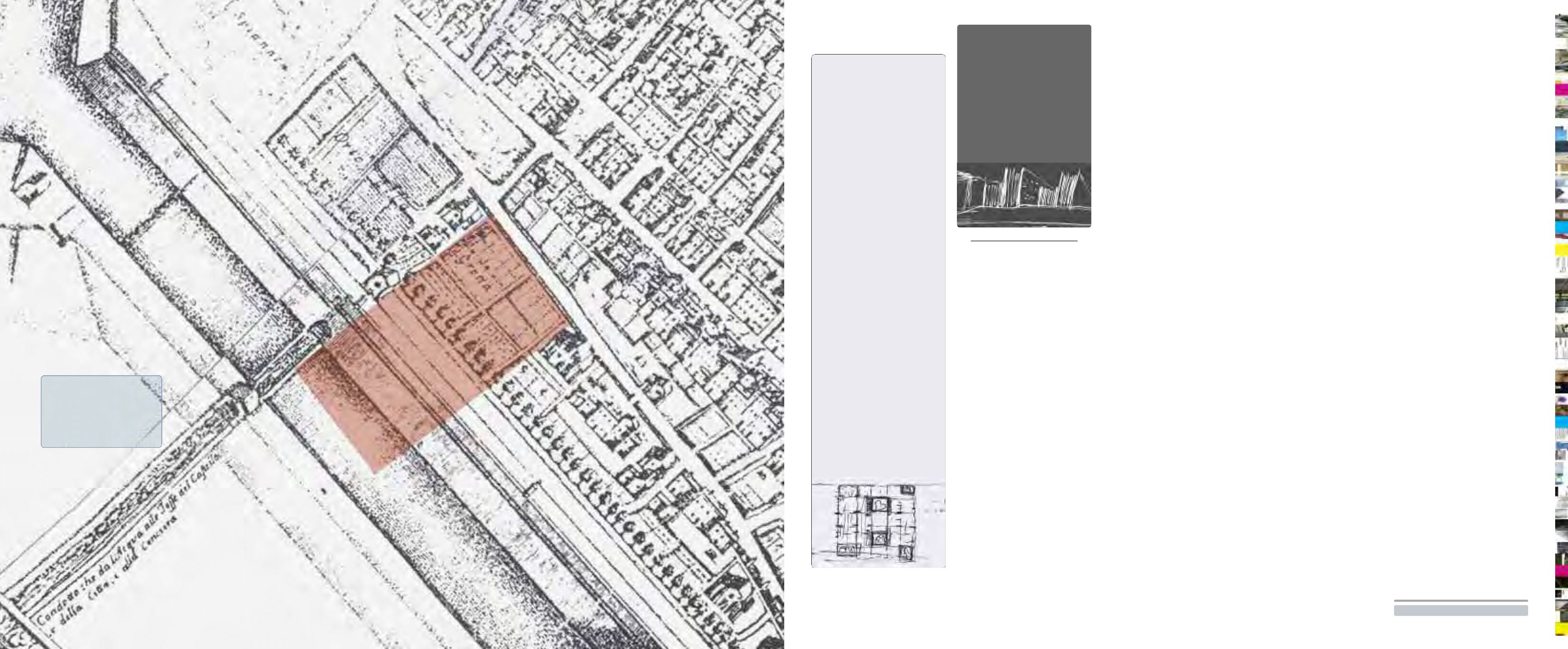
Pianta di Andrea Bolzoni,
1747, particolare
Andea Bolzoni’s map,
1747, detail
Il luogo.
Inquadramento
urbano e previsioni
urbanistiche dell’area


