39
ferrarese, nel tratto di attraversa-
mento urbano della città di Fer-
rara, dove emerge con grande
forza il tema della ridefinizione del
water front
della città verso il suo
fiume.
A tal fine la progettazione pre-
vede, oltre al rifacimento degli ele-
menti spondali, anche nuovi colle-
gamenti ciclopedonali, e valorizza
quale elemento trainante del pro-
getto il luogo della nuova Darsena
fluviale, nuovo cuore pubblico,
con funzione di spiaggia urbana,
che conferisce una rinnovata cen-
tralità alla città storica che si riaf-
faccia al suo fiume.
Per accelerare ulteriormente i pro-
cessi di riqualificazione di tali aree,
con l’intento di acquisire una pro-
gettazione di qualità, nel luglio
2007 l’Amministrazione comu-
nale, costituisce una Società di
Trasformazione Urbana (STU) con
il compito di affrontare il recupero
dei tre ambiti denominati Palazzo
degli Specchi, ex Mof-Darsena ed
ex AMGA.
Successivamente viene bandita una
gara di progettazione europea,
aggiudicatasi dall’associazione di
imprese Behnisch Architecten e
Politecnica Ingegneria e Architet-
tura, che nel settembre 2008 con-
segnano una prima stesura del
masterplan, cui è seguita nel 2010
la progettazione dei relativi Piani di
Recupero.
Gli elementi guida del progetto
urbanistico sono conformi a quelli
dettati del Piano Strutturale
Comunale, ovvero «una città effi-
ciente, capace di garantire ai suoi
cittadini, ma anche alle diverse
popolazioni che la abitano, la visi-
tano e la usano una migliore qua-
lità dell’ambiente e della vita tale
da produrre essa stessa ric-
chezza», che nel prefigurare l’as-
setto futuro del territorio comu-
nale, si conforma principalmente
a tre principi guida:
• “Lavorare sulla città esistente”,*
riqualificandola e compattandola,
rafforzando l’asse insediativo “est-
ovest”, connesso alla nuova linea
di ferrovia metropolitana.
• “Espandere il centro” portando
la qualità del centro al resto della
città, esportando quindi, nelle
parti urbane esterne, la qualità, la
Architettura, who in September
2008 produced the first draft of
the masterplan. This was followed
in 2010 by the plans for the
relevant Redevelopment Plan. The
guiding elements of the urban
project are those detailed in the
Municipal Structural Plan, which
aims to foster: “an efficient city,
able to guarantee to its citizens,
and even the different groups who
live there, visit it, or use it, a better
quality of environment and of life
such that it is self-enriching,”
thereby laying out this future asset
of the municipal territory according
to three guiding principles:
• “Work on the existing city”,*
redeveloping and condensing it,
reinforcing the east-west axis of
settlement, connecting to the new
metropolitan train line.
• “Expanding the centre” bringing
the quality of the centre to the
rest of the city, exporting to the
urban periphery the quality, den-
sity and mixture of functions, serv-
ices and facilities that are available
in the historical centre.
• “Establish networks and connec-
tions” working on reconnecting
sections of networks and urban
areas, through network mobility,
environmental systems and public
spaces. In particular the environ-
mental systems assume a struc-
tural role not only for the correct
ecological functioning of the terri-
tory but also for a more livable
city, so the reconnection of the
public spaces becomes the driving
strategy of the new plan.
The main objective of the plan,
therefore, is to develop the quality
of life through the project
proposal, which is based upon
sustainability that encompasses
the new life styles and the quest
for innovative planning solutions.
The report of the project proposal
describes how the “connection of
the area of the ex-Mof and the
river basin in proximity to the
medieval city constitutes a strong
conceptual starting point, in terms
of relations between the built up
and the free spaces (roads, squares,
open spaces) and in the way in
which these organize perceptions of
38
L’insieme degli insediamenti
sopradescritti, specie in considera-
zione della loro collocazione stra-
tegica tra la città storica e le prime
periferie della città, è stato da
subito individuato come un vero e
proprio sistema di luoghi da riqua-
lificare dal Piano Regolatore del
1995, che fondava la propria prin-
cipale strategia sul recupero degli
spazi compresi tra la città murata
e il Po di Volano.
La loro valenza strategica viene
definita concettualmente nel
1996, anno successivo all’appro-
vazione del PRG, nel convegno “V
come Volano”, dove viene teoriz-
zato il nuovo ruolo che tali aree
dovranno assumere per l’intero
agglomerato urbano; il loro essere
baricentriche rispetto alla città sto-
rica ed alla città del Novecento,
lascia immaginare il costituirsi di
una nuova centralità, una sorta di
nuovo asse della Giovecca, dove
collocare quelle nuove funzioni di
cui il centro storico necessita.
Questa caratterizzazione viene
confermata con la Legge regio-
nale n. 19 del 1998, dove tali luo-
ghi divengono prioritari per il Pro-
gramma di Riqualificazione
Urbana (PRU), e rappresentano
uno dei primi tentativi di attivare le
trasformazioni urbane attraverso
virtuose sinergie tra interventi pri-
vati, comunali e finanziamenti
regionali.
Ed è proprio nell’ottica di recuperare
questi ambiti strategici che l’ammi-
nistrazione comunale si fa promo-
trice, assieme alla Provincia di Fer-
rara, di un concreto avvio del pro-
cesso di riqualificazione dell’idrovia
vision was supported by regional
law number 19 in 1998, in which
the area was given priority in the
Urban Redevelopment Program
(PRU), thereby representing one of
the first attempts to kick start urban
renewal through virtuous synergies
between projects that are private,
municipal and regionally funded.
It is exactly within the framework of
recovering these strategic spaces
that the municipality became the
promoter, together with the Province
of Ferrara, of a concrete starting
point with the redevelopment of
that section of Ferrara waterways
where they cross the city, redefining
the water front where the river
emerges with great force.
To this end, the project foresaw, in
addition to the restoration of the
riverbanks, new pedestrian/cycle
paths, and which enhanced the
driving forces behind the project
for the new river basin, creating a
new heart for the city, with urban
beaches that would give the
historical city on the restored river
new prominence.
To facilitate the redevelopment of
this area and with the intention of
obtaining a project of high quality,
in July 2007, the municipal
administration
formed
the
Company for Urban Development
with the aim of addressing the
redevelopment of the three areas
locally known as the Palazzo degli
Specchi, the ex-Mof-Darsena and
the ex-AMGA.
These were put out to a Europe-wide
tender, which was won by the firm
Behnisch Architecten in association
with Politecnica Ingegneria e
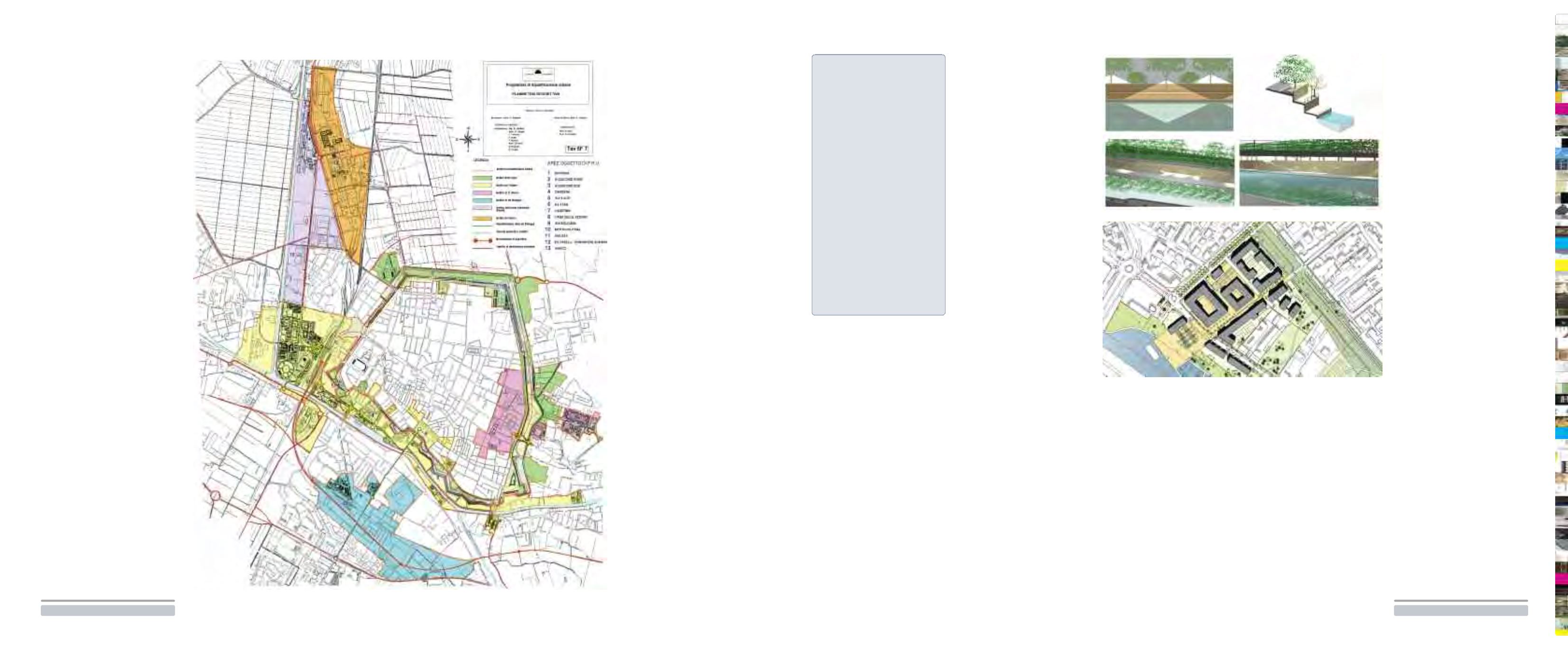
Immagine del progetto di
riqualificazione dell’idrovia nel
tratto urbano, rendering
Picture of the waterways
project in the urban section,
rendering
Planimetria dei Piani di
Recupero delle aree ex Mof-
Darsena
Draft plans for redeveloping
the ex-MOF and the river basin
< Ambiti coinvolti nel
Programma di Riqualificazione
Urbana (PRU)
< Areas included in the Urban
Redevelopment Program
project


